How Drone Photography is Transforming NYC Real Estate Marketing
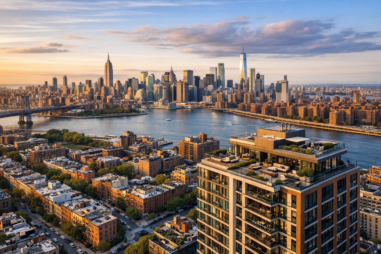
Drone photography captures a breathtaking view of NYC's skyline at sunset, highlighting the mix of iconic skyscrapers and urban landscape adjacent to the river.
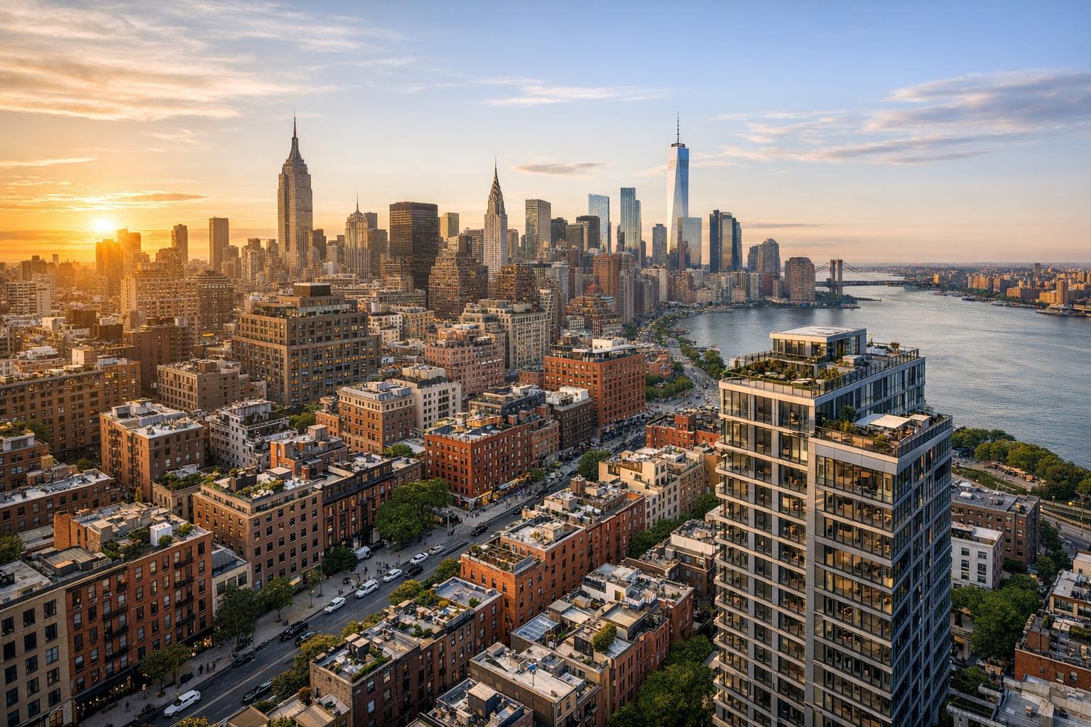
Drone Photography NYC: Elevating Real Estate Marketing with Aerial Perspectives
In today’s fast-paced market for real estate photography in NYC, staying ahead means highlighting properties with every visual advantage. From sweeping penthouse shots to intimate backyard views, drone photography NYC is rapidly redefining the way agents and property owners present listings—and driving engagement in one of the most competitive markets in the world. In this post, you’ll discover how aerial imagery is changing the game, what it means for your listing’s perceived value, and how to get the most out of professional drone real estate photos. You'll also learn practical compliance tips, emerging trends, and how RealtaSnap makes world-class aerials accessible for every project.
The Problem: Standing Out in a Densely Competitive NYC Market
NYC real estate moves fast—and so do buyers’ expectations. Standard ground-level photography, no matter how skilled, can leave listings looking similar and uninspired, especially in high-rise-packed boroughs or among townhomes with hidden outdoor gems. Without dynamic real estate aerial photography, crucial features like amenities, proximity to landmarks, and panoramic views are left unseen. This creates several problems:
- Listings blend together: Ground photos can’t fully capture a property’s advantages.
- Reduced engagement: Potential buyers may skip over ordinary-looking listings.
- Lost perceived value: Neighborhood context, rooftop terraces, and private gardens go unnoticed.
- Missed storytelling: NYC’s unique verticality and skyline are rarely showcased.
These challenges can result in longer days on market, lower selling prices, or frustrated sellers who expect more from their agent’s marketing.
How RealtaSnap Solves It
With RealtaSnap’s advanced drone photography NYC and real estate aerial photography packages, agents and owners gain a powerful edge. RealtaSnap photographers use the latest FAA-licensed drones to create cinematic aerials that tell your property’s full story—from above, around, and within the vibrant NYC landscape. Every shoot is carefully planned to highlight architectural features, outdoor spaces, and views that simply aren’t possible with ground-level photos alone.
Because we specialize in real estate drone photography (serving both NYC and Northern NJ), you get work that balances artistry with compliance—delivering eye-catching results that meet all NYC regulations. And even better, with RealtaSnap, you can pair aerials with HDR interiors, cinematic walkthroughs, and more—all delivered in as little as 24 hours.
Discover the full suite of RealtaSnap’s New York drone and real estate photo services here.
Key Benefits of RealtaSnap’s Drone Real Estate Photos
- Effortlessly showcase skyline and park views.
- Highlight outdoor amenities like pools, decks, and gardens.
- Underscore property location to transit, parks, or waterfronts.
- Capture context of nearby streets, landmarks, or unique features.
- Appeal to buyers seeking homes with specific lifestyle or scenery.
- Stand out in crowded MLS feeds and high-traffic listing sites.
- Fast, fully edited delivery—images typically within 24 hours.
- Professional, FAA-compliant operations for every NYC borough.
Comparison with Competitors & Traditional Services
Where many traditional real estate photographers rely on ground-based imagery, RealtaSnap brings your listings to life from every angle. Unlike basic photo providers or slow delivery services, RealtaSnap combines speed (with many aerial shoots returned in just one business day), exceptional image quality, and a seamless client experience tailored for New York’s unique marketing needs. Plus:
- Dedicated NYC expertise: Deep knowledge of borough-specific aerial rules and best practices.
- A la carte pricing: Only pay for what you need; full pricing and package details are always upfront.
- Integrated media options: HDR, video, and aerials—all in one booking.
- No long waits: Quick turnaround, even for complex shoots.
All prices and information are subject to change. Information is deemed reliable but not guaranteed.
Getting the Most from Drone Real Estate Photography in NYC
Even with professional tools, maximizing the impact of real estate aerial photography takes insider know-how. Here are tips to optimize your aerials:
- Schedule flights for early morning or golden hour for dramatic lighting.
- Prepare outdoor spaces: clear patios, trim landscaping, tidy rooftop elements.
- If allowed, coordinate with neighbors for unobstructed shots of shared amenities.
- Communicate your property’s selling points ahead of time so aerial shoots can tailor their agenda.
- Use drone real estate photos strategically for hero shots and website banners.
- Ensure your provider, like RealtaSnap, is fully compliant with local drone regulations—including FAA and NYC-specific restrictions for certain airspaces.
Compliance & Legal Considerations in NYC
NYC has some of the strictest drone rules in the country, especially around airports, large events, bridges, and notable landmarks. Only FAA-certified pilots are permitted to fly drones commercially, with further restrictions on specific zones in Manhattan, Brooklyn, Queens, and The Bronx. Unauthorized or amateur flights can risk fines and liability issues. That’s why it’s essential to partner with a provider who understands the legal landscape—ensuring every flight is safe, insured, and regulation-friendly.
Emerging Trends in NYC Drone Photography
- Dynamic video tours: Aerial “fly-in” and “fly-through” videos showcasing movement from above street-level into the property.
- Interactive virtual walkthroughs: Pairing aerials with immersive 3D tours.
- Neighborhood storytelling: Mini-documentaries using voiceover and overlays to highlight local attractions and transportation.
- Architectural studies: Using drone perspectives to illustrate development potential in up-and-coming neighborhoods.
- Eco-highlighting: Demonstrating solar panels, green roofs, and landscaping with environmental appeal.
As technology advances and buyer expectations rise, these techniques will quickly become standard in high-performing listings.
Conclusion & Call to Action
If you want your NYC listings to rise above the competition, drone photography is more than just a trend—it’s a new standard for modern real estate success. With RealtaSnap, you can unlock breathtaking aerial perspectives, rapid delivery, and peace of mind that every flight is handled by experts who know the city’s unique landscape—literally and legally.
Ready to transform your next listing with aerials that grab attention and boost value? Book your RealtaSnap drone session today and see how easily you can elevate your property marketing.
Frequently Asked Questions
1. Isn’t drone photography too complicated or risky to arrange in NYC?
It can seem overwhelming with city regulations and airspace rules, but RealtaSnap handles all compliance and insurance, making the process simple and secure for your listing.
2. Won’t my property look out of place compared to other listings if I use aerial shots?
Some worry drone images may not match standard listing formats, but RealtaSnap delivers photos and videos optimized for MLS, social media, and digital platforms to ensure your listing looks polished, professional, and inviting.
3. Is drone photography really worth it for just one property?
You might think aerials are only for luxury listings, but with RealtaSnap’s transparent, a la carte pricing, everyone can add value with striking drone perspectives—no matter the property size or budget.