Why Drone Photography Is Transforming NYC Real Estate Listings
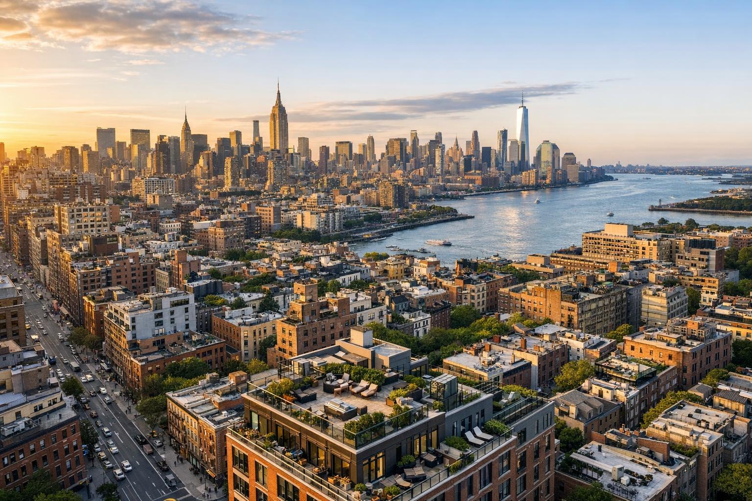
Drone photography captures a stunning view of New York City's skyline and waterfront, showcasing the dense and vibrant real estate landscape.

Why Drone Photography Is Transforming NYC Real Estate Listings
Drone photography real estate services are reshaping the way New York City properties are presented to buyers and tenants. While traditional ground-based photography captures a property’s interior charm and curb appeal, aerial imagery reveals so much more. In a dense urban landscape like NYC, knowing how a terrace hangs above a tree-lined street or how a condo relates to the skyline can elevate a listing from ordinary to memorable.
Here’s a closer look at why drone media matters for local real estate marketing, how it’s actually used, and what to consider before booking an aerial shoot for your next listing.
Seeing the Bigger Picture: What Aerial Imagery Adds
Standard interior photography excels at showcasing finishes, light, and space, while exterior shots highlight curb appeal or building entry. But they’re limited by the camera’s viewpoint. That’s where aerial real estate photography steps in. By changing perspective, drone images can reveal features such as:
- The relationship between a home and its outdoor space: gardens, decks, pools, and courtyards
- Architectural details by showing rooflines, facades, and the broader streetscape
- The size and layout of a commercial property or development site
- Proximity to green space, water, or open views
- The setting of a rooftop deck or private terrace
- Orientation of a property within its block or relative to landmarks
For listings where outdoor features or unique locations drive value, drone coverage does what street-level photos cannot. Instead of simply hinting at a terrace’s appeal, for example, a well-composed drone shot can show how the space sits above the neighborhood, faces a landmark, or remains private from street traffic.
NYC’s Unique Visual Challenges — and Drone Solutions
Marketing real estate in New York comes with obstacles. Buildings crowd together, leafy streets obscure lower floors, and a property’s best views often can’t be appreciated from the lobby. Aerial images are especially effective for listings that benefit from broader context or visual storytelling.
Brownstones, Townhomes, and Historic Buildings
A Brooklyn brownstone with a lush rear garden or a Harlem townhouse with a rooftop addition simply looks different from above. Aerial shots highlight not just the architecture but also how the building relates to surrounding homes, gardens, and the block itself. That wide perspective can bring out features that standard photography might overlook—historic cornices, brickwork, or an unusually spacious lot.
Condos and Penthouses With Outdoor Spaces
In Manhattan, Long Island City, Williamsburg, and Downtown Brooklyn, a skyline view or a generous terrace is often the selling point. Drone media helps highlight:
- Private terrace or rooftop orientation
- The expanse and usage of outdoor amenities
- A building’s relationship to city parks or waterfront
- Sightlines over neighboring rooftops
It’s worth remembering that great aerial photos don’t just mean reaching new heights. The most useful images clarify important features, not just the tallest ones.
Commercial Listings and Development Sites
When it comes to commercial or multi-building sites, aerial photos can make an immediate difference. From illustrating access points and parking layouts to revealing the relationship between multiple structures, drone media can help developers, property managers, and tenants understand the bigger picture. Aerial video is also valuable for capturing site scale or showcasing key transit corridors nearby.
Video or Still? Using Movement for Orientation
Still images are powerful for zeroing in on unique features, but aerial video introduces movement and orientation. With a well-planned sequence, viewers see how a property is situated in its neighborhood—pulling in from the skyline, moving across a terrace, or circling a garden. If you’re already considering a “real estate videography near me” search, pairing walkthrough video with drone segments allows you to set the stage with exterior context before guiding viewers inside.
- Interior walkthrough video: Shows layout, finishes, and room flow
- Exterior ground-level video: Highlights entrance, landscaping, and curb appeal
- Aerial video: Delivers context, orientation, and scale
Mixing and matching these formats often results in a more engaging and complete presentation.
When Aerial Media Makes Sense (And When It Doesn’t)
Not every NYC property needs drone coverage. For a studio without views or a building where exterior features don’t add impact, interior photography or a virtual tour might be your best investment. However, drone media is usually worth the effort when listings feature:
- Rooftop decks, terraces, yards, or significant outdoor space
- Waterfront, park-facing, or skyline views
- Distinctive or architecturally notable properties
- Large parcels or multiple-building developments
- Commercial listings where access and context are essential
Choosing the right package—and using each medium for its strengths—leads to a listing that feels custom-tailored, not generic.
Planning and Preparing for NYC Drone Shoots
Aerial real estate photography isn’t a matter of simply showing up with a drone. In New York City, flight feasibility depends on FAA rules, airspace conditions, weather, site access, and other safety considerations. Pilots must review each location carefully, with roof access often making a shoot more likely but never guaranteeing it. Some properties may need special municipal or event permits, which are the client’s responsibility to obtain if required.
Preparation at the property is just as important for a successful aerial shoot:
- Clear patios, decks, balconies, and roofs of unnecessary items
- Remove trash bins and maintenance equipment from visible areas
- Arrange outdoor furniture neatly
- If possible, keep vehicles out of major sightlines
- Coordinate access to any shared or locked outdoor spaces
A few minutes of prep helps ensure that the finished images accurately represent the property and highlight its best features.
Selecting the Right Drone Media Package
With RealtaSnap, agents and property managers can choose the drone service that suits the listing’s goals:
- Drone photography: 10 professional HDR images with blue sky replacement if needed ($209)
- Drone video: A one-minute final 4K video ($229)
- Photo and video bundle: 10 aerial photos plus a one-minute 4K video ($299)
For listings that warrant both detailed imagery and a shareable video segment, the photo-and-video bundle is a practical way to get a balanced set of assets. Still images perform well in MLS galleries, while video can amplify your reach through websites, email marketing, and social channels.
Find more details about RealtaSnap’s NYC drone photography and aerial media options.
Making the Most of Drone Media in Your Listing
A compelling real estate presentation is always a team effort between different media types. Interior images showcase living spaces, a floor plan gives viewers spatial orientation, and drone imagery situates the property in its wider setting.
Picture a Brooklyn townhouse: interior shots highlight renovations, a floor plan explains the layout, and drone images reveal the relationship between the home, garden, and block. Or a Manhattan penthouse, where interior photography shares the finishes and light, while aerial video sets the scene among the rooftops and skyline. Each format does its own job, helping viewers fully appreciate the property.
Practical Considerations for NYC Drone Work
Given the complexities of city airspace and safety requirements, booking drone photography in NYC often requires flexibility and clear communication. Not every listing will qualify for a flight, and conditions can change with weather, events, or local restrictions. RealtaSnap evaluates each assignment carefully and communicates feasibility upfront, so there are no surprises.
For a complete rundown of services and to check options for your next NYC listing, visit www.RealtaSnap.com.
FAQ
Question: Can drone photography be used for every NYC real estate listing?
Answer: Not always. Drone flights in New York City are subject to airspace restrictions, weather, access, safety, and pilot discretion. Some addresses—especially in dense or restricted zones—aren’t suitable for drone operations.
Question: What kinds of properties benefit most from aerial real estate photography?
Answer: Properties with outdoor spaces, terraces, distinctive architecture, large parcels, multiple buildings, or a strong location advantage (like waterfront or skyline views) tend to gain the most from aerial imagery.
Question: Can I combine drone filming with interior video tours?
Answer: Absolutely. Aerial video can set the exterior scene for your listing, while interior videography covers room flow and finishes. Together, they give potential buyers or tenants a well-rounded sense of the property.
If you have an NYC listing that would benefit from drone media, we’d be happy to help assess your options and capture what makes the property unique.