When Is Drone Photography Worth It for a Real Estate Listing?
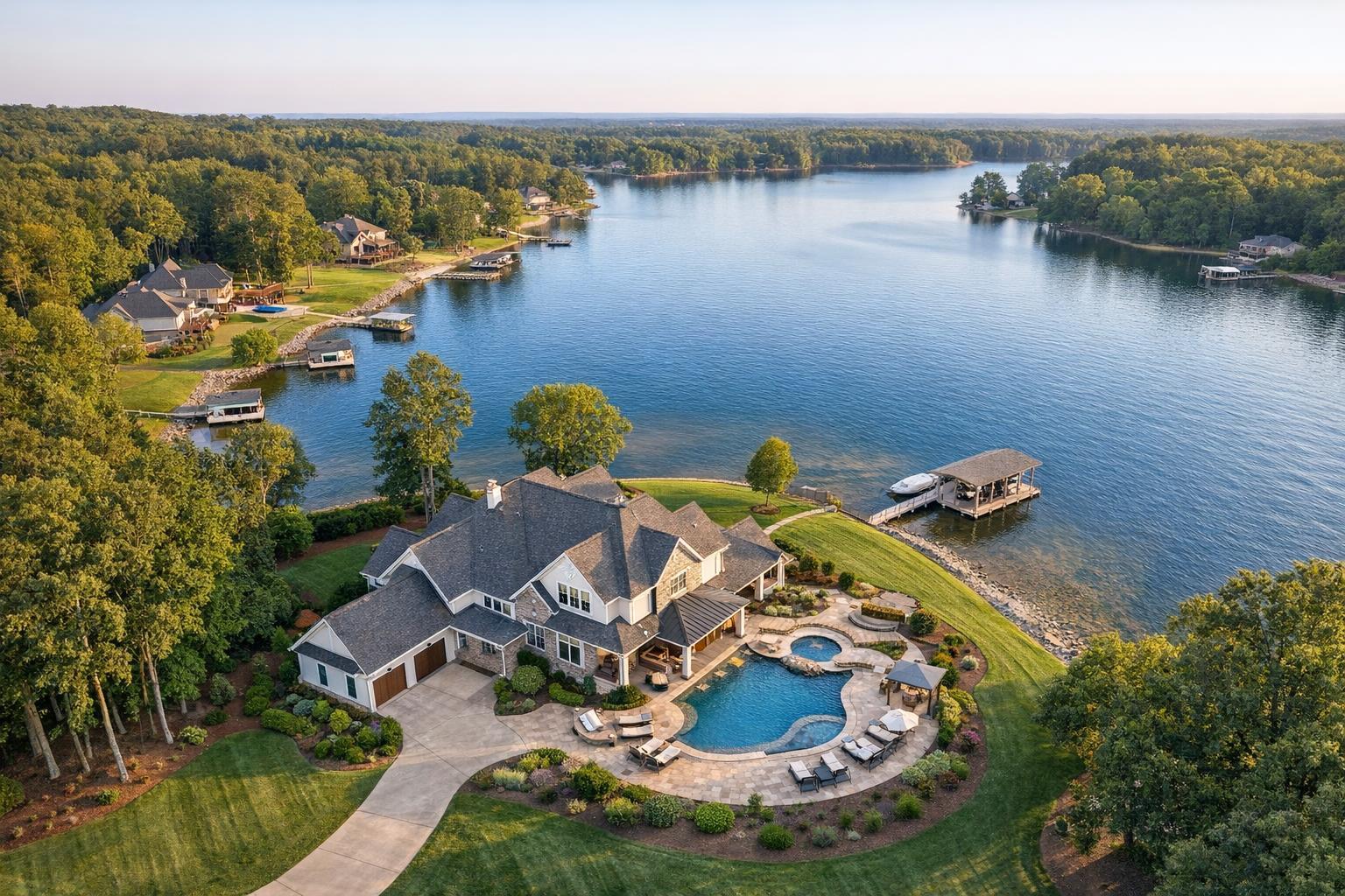
Drone photography showcases a luxurious lakeside property with a spacious house, beautifully landscaped gardens, and a private dock.

When Is Drone Photography Worth It for a Real Estate Listing?
Drone photography real estate often sparks curiosity from agents and sellers alike—when does an aerial perspective genuinely add value, and when might it be unnecessary? With so many listing media options available today, deciding whether to include drone photography is less about following a trend and more about how well aerial visuals support the story of your property.
Let’s explore when real estate drone photography services provide real benefits, which property types usually benefit most, and how to assess whether drone media fits your next listing.
What Drone Imagery Can Actually Show
Traditional listing photos focus on showcasing interior rooms, finishes, and the feel of each space. Curb-level exterior shots cover important details like entrances, patios, and street presence. Drone photography steps back to reveal the bigger picture—how the pieces fit together on the property and in the neighborhood.
The right aerial images answer practical questions, such as:
- How does the home’s footprint relate to the rest of the lot?
- What’s the proximity to water, parks, or amenities?
- Which outdoor areas, like pools or decks, are part of the property?
- Is there a unique architectural layout not visible from the street?
When chosen thoughtfully, drone photos or short aerial video clips clarify size, setting, and relationship to features like a pool, garden, or waterfront—not just adding drama, but genuinely helping buyers understand the space before visiting.
Listings That Benefit Most from an Elevated View
Not every listing needs a bird’s eye view. Drone coverage is most compelling when the aerial perspective brings something new or meaningful to light.
Larger Properties and Estates
Homes on expansive lots often outgrow the limitations of ground-level photos. Aerial images make it much easier to grasp details like:
- The length of driveways and placement of detached garages or guest cottages
- How a pool, patio, and yard connect with the main house
- The expanse of landscaped or wooded grounds
If your New Jersey or suburban NYC property sits far from the road or offers multiple outdoor amenities, aerial photography can tie it all together in one glance.
Waterfront and View-Oriented Listings
Whether the property sits on a lake, near the shore, or boasts reliable skyline or park views, location matters. An aerial shot can instantly convey what’s unique about the setting—such as direct access to a beach, proximity to marinas, or the orientation of the house toward a prized panorama. This perspective is all about showing honest context, not exaggerating features.
Outdoor Amenities and Distinctive Architecture
Listings with extensive entertaining spaces, multi-building layouts, or striking rooflines often look more impressive from above. Drone shots help buyers visualize the flow between:
- Pools, terraces, fire pits, and other outdoor gathering spaces
- Tennis or sport courts
- Large landscaped gardens
- Unusual roof architecture, courtyards, or additions
For architect-designed homes or properties set on sloped or irregular lots, a drone image can reveal forms invisible from the curb.
Commercial and Development Properties
On the commercial side, aerial media often helps explain land use, access points, parking configurations, and visibility from major roads. For larger sites, this can be far clearer than a collection of ground-level images.
When Drone Coverage May Not Be a Strong Fit
While the aerial view is powerful in some cases, it isn’t automatically the right investment for every property. For listings where the true selling points are interior space, finishes, or in-building amenities—especially in dense urban areas like Manhattan or downtown Jersey City—drone photos can sometimes feel disconnected or redundant.
Consider factors such as:
- Does the exterior story truly add to the marketing narrative?
- Is there enough space, land, or view to make a distant perspective meaningful?
- Would a tightly focused set of professional interiors or a video walkthrough be more effective for the target buyer?
For a small townhouse, the best exterior shot may come from street level, with drone coverage adding little value.
Special Considerations for Dense Urban Listings
Drone rules in New York City and urban New Jersey are a story of their own. In dense areas, several challenges can affect feasibility:
- Limited exterior land (especially in high-rise buildings or small lots)
- Airspace restrictions, including FAA regulations and local rules
- Difficulty finding safe and legal launch points
- The need for roof access—which helps, but isn’t a guarantee
Even with roof access, variables like weather, local safety, and pilot assessment matter. Often, for urban apartments, interior visuals, building amenity shots, floor plans, or virtual tours become the best way to showcase what buyers care about.
How Drone Flights Are Evaluated
Every real estate drone shoot is subject to a unique set of conditions. Here’s what typically factors into the decision:
- Airspace: RealtaSnap follows FAA Part 107 rules. Controlled or restricted airspace requires specific permissions and may limit availability.
- Weather: Wind, rain, and low visibility affect both image quality and safety.
- Safety & Access: There needs to be a safe spot to take off and land—often easier with yard or roof access.
- Permitting & Local Rules: Some projects may require approvals beyond FAA clearance. RealtaSnap does not obtain special municipal, NYPD, or event permits.
- Pilot Discretion: The pilot always makes the final call about whether a flight is possible and safe.
Drone work for real estate in NYC and New Jersey is always evaluated case by case. Just because a property looks like a good candidate from the ground doesn’t guarantee that aerial media is feasible or allowed.
Planning for Effective Aerial Coverage
If you think aerial property photography could help your listing, it’s best to start with the property’s story in mind. Pinpoint what you want buyers to see—be it a sweeping lot, the link between a backyard and lakefront, the full extent of outdoor amenities, or the context of a commercial site.
When planning, consider these preparation steps:
- Identify which features need an overhead or high-angle view
- Coordinate any needed access, such as roof entry for condos or high-rises
- Communicate your goals clearly to your media team
- Think about pairing drone stills with interior or exterior ground photography for a complete visual package
The best drone shots serve a specific, practical purpose—not just an extra angle but a genuinely helpful view.
Budgeting for Drone Media in NYC & New Jersey
Pricing for real estate drone photography services is much clearer when you link it to your goals. RealtaSnap currently offers:
- 10 high-dynamic-range (HDR) drone photos for $209
- One-minute 4K drone video for $229
- A combined photo-and-video option for $299
Blue-sky replacement is included for drone photos when needed. Drone deliverables work best when you have a story to tell with them—a waterfront home may benefit from both stills and video, while a well-shaped two-acre lot may only require a handful of aerial images.
For more about RealtaSnap’s exact drone services and to check if your property fits, see RealtaSnap’s aerial media information.
Bringing It All Together
Drone photography can be a cost-effective way to spotlight the features that make a property special, but only when used for the right reasons. Thoughtful aerial media provides context—not just eye candy—by illustrating a lot’s shape or amenities, a home’s relationship to outdoor spaces, or the placement of a building relative to its neighbors.
Before committing, take a moment to decide if an elevated view supports your marketing goals. Many listings shine with classic ground-level photography and a well-sequenced walkthrough video. For properties where aerial shots matter, starting early in your planning helps ensure smooth approval and the best results for your listing.
Have a property in NYC or New Jersey you’d like to discuss? Visit RealtaSnap to get the conversation started or book your shoot. Aerial media is often most impactful when it’s considered early, so your listing’s story can be captured fully and clearly.
FAQ
Question: Is drone photography needed for every property listing?
Answer: Not at all. Drone coverage makes the most sense when it reveals land, outdoor amenities, or context that ground-level images can’t show. For compact properties or listings focused on interiors, traditional photography and video are usually more effective.
Question: Can I guarantee drone coverage for a Manhattan apartment?
Answer: No, drone flights in NYC are subject to FAA rules, local restrictions, weather, airspace, property access, and pilot discretion. Roof access may help, but feasibility is always determined case by case, and approval is never automatic.
Question: Should I book drone photos, video, or both?
Answer: It depends on the story you want to tell. Choose drone photos for clear, lasting views of the lot, a pool, or outdoor features. Use video if you need to capture movement, approach, or setting. For properties with a strong exterior narrative, both photo and video can be a great fit.
For more details or to get started, visit www.RealtaSnap.com.