Why Drone Photography is Transforming NYC Real Estate Marketing
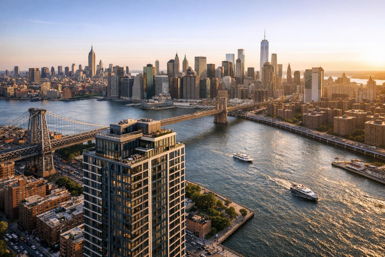
Captured through drone photography in NYC, the image showcases a stunning aerial view of the city's skyline with the Brooklyn Bridge and East River highlighting the scene.

How Drone Photography in NYC Is Transforming Real Estate Marketing
Real estate photography in NYC is rapidly embracing advancements like drone photography to tell more captivating stories and sharpen the competitive edge of every listing. In today’s post, we’ll explore how drone photography is changing the game for real estate marketing in NYC, highlight the unique benefits of aerial real estate photography, and share expert strategies for maximizing visual impact while staying compliant in New York City’s busy, often restricted airspace. You’ll learn why working with a professional team like RealtaSnap makes all the difference—and how you can use drone imagery to outshine the competition in Manhattan, Brooklyn, Queens, and beyond.
The Problem: Standing Out in a Hyper-Competitive NYC Real Estate Market
With thousands of properties hitting the market each month, real estate marketing in NYC is tougher than ever. Static, ground-level photos rarely capture the full story of a property—especially in a city defined by its verticality and dramatic skylines. This creates big challenges:
- Listings blend together and fail to catch buyers' eyes.
- Unique features—like private rooftops, gardens, or a building’s proximity to parks—get lost.
- Homes with only interior shots can feel cramped or disconnected from their neighborhood context.
- DIY drone attempts can lead to legal headaches in tightly regulated NYC airspace.
In a digital-first market where buyers often decide within seconds whether to investigate further, relying on traditional photography alone is a recipe for a stale, overlooked listing.
How RealtaSnap Solves It: Expert Drone Photography for Impactful NYC Listings
RealtaSnap delivers premium aerial real estate photography across New York City with a streamlined, fully compliant approach. Our licensed drone pilots excel at navigating regulatory complexity while capturing the wide, high-impact shots that give every listing a true sense of place. We combine state-of-the-art 4K and HDR drone technology with local market insight—presenting properties in the most striking, memorable light possible.
Why trust RealtaSnap with your NYC aerial real estate photography?
- All drone operations are conducted by FAA Part 107-certified pilots.
- We assess each location for flyability, manage airspace permissions, and ensure safety at every step.
- Our drone services help contextualize your property—showing proximity to landmarks, water views, community amenities, and cityscape vistas buyers crave.
- We deliver fully edited HDR aerial photos and cinematic 4K videos within 24 hours, every time.
Learn more about our full-service solutions on our NYC drone photography and videography page.
Benefits of Choosing RealtaSnap’s Drone Photography
- Professional pilots ensure full FAA and NYC compliance.
- Fast delivery: fully edited drone photos/videos in 24 hours.
- High-resolution 4K imaging for maximum listing impact.
- Highlight proximity to parks, rivers, subways, and landmarks.
- Showcase rooftops, amenities, and views others miss.
- Flexible shoot options: photos, videos, or both in one visit.
- HDR and blue-sky sky replacement for every image.
- No permit or municipal paperwork stress for agents.
- Simple, transparent pricing for every project.
All prices and information are subject to change. Information is deemed reliable but not guaranteed.
Use Cases for Drone Photography in NYC Real Estate Marketing
- Luxury Condos & Penthouses: Show off panoramic skyline views, rooftop lounges, and private terraces.
- Townhouses: Capture tree-lined blocks and neighborhood charm from above.
- Development Sites: Provide investors with a detailed visual overview of property positioning and area growth.
- Commercial Real Estate: Emphasize accessibility, transit proximity, and surrounding retail.
- Marketing New Developments: Offer buyers a sense of future lifestyle—community parks, walkability, and recreation all in one frame.
Aerial perspectives are especially useful for highlighting architectural uniqueness, value-added amenities, and the true relationship between the property and its neighborhood environment.
Best Practices and Tips for Maximizing Drone Photography Impact in NYC
- Plan for Compliance: Not all NYC locations are flyable due to airspace restrictions. Always work with a provider who understands FAA regulations, local no-fly zones, and specific NYC permits. RealtaSnap screens every project for feasibility and handles all drone operations with full legal compliance.
- Secure Roof Access: In dense boroughs, building and roof access dramatically expands the quality and angles of drone shots. Coordinate with building management in advance to maximize shot creativity.
- Timing Matters: Schedule shoots during golden hour for dramatic lighting that flatters both property facades and city backdrops. For especially vibrant results, RealtaSnap offers flexible time slots—including sunrise and sunset sessions.
- Show More Than the Property: Use aerial shots to include neighborhood amenities—parks, waterfronts, schools, or transit—for added buyer context.
- Pair with Ground Photography: For the most immersive listings, combine drone imagery with professional interiors and exteriors to create a seamless, visually rich story.
- Highlight Unique Amenities: Showcase terraces, pools, playgrounds, or green roofs that differentiate the property.
- Consistent Branding: Use video editing and blue sky replacement to maintain a polished, cohesive look across all listing marketing.
Why RealtaSnap Stands Out from Traditional and Competing Services
Unlike ad hoc drone pilots or traditional photographers, RealtaSnap provides an elevated, client-focused experience:
- Faster Delivery: Receive finished aerial photos and 4K video within 24 hours—not days.
- Unmatched Quality: Every shoot includes HDR editing and sky replacement, so every shot pops.
- Streamlined Booking: Choose your services online and confirm within minutes. See how to schedule your shoot.
- Clear Compliance: We make regulatory hurdles invisible to you—pilots are licensed and experienced in NYC’s unique drone landscape.
- Comprehensive Service: Get aerials, interiors, exteriors, and more from a single coordinated team—no fragmented vendors or inconsistent results.
Conclusion: Elevate Your NYC Listings with RealtaSnap Drone Photography
In a city as visually striking and competitive as New York, your listings deserve a higher perspective. Professionally executed drone photography not only attracts more eyes but creates a compelling, emotional narrative around your property—an essential edge in today’s real estate marketing. Trust RealtaSnap to deliver seamless, impactful aerial media and drive meaningful results for your next listing.
Discover what professional drone photography can do for your NYC marketing strategy. Visit www.realtasnap.com or book your drone shoot today.
Frequently Asked Questions
1. Isn’t drone photography too complicated (or risky) in New York City?
Many assume it’s impossible or too bureaucratic, but RealtaSnap’s FAA-certified pilots manage all compliance, so you get high-impact aerials, worry-free.
2. What if my building is in a no-fly zone or has roof restrictions?
Not every spot is drone-feasible, but RealtaSnap always conducts airspace checks and coordinates for location-specific solutions—often finding creative alternatives for your listing.
3. Are drone listing photos and videos worth the investment?
Some think aerials are just for luxury homes, but with RealtaSnap’s clear, service-oriented pricing, NYC properties at every level can stand out and sell faster.