Drone Photography NJ: When Aerial Media Makes Sense for a Listing
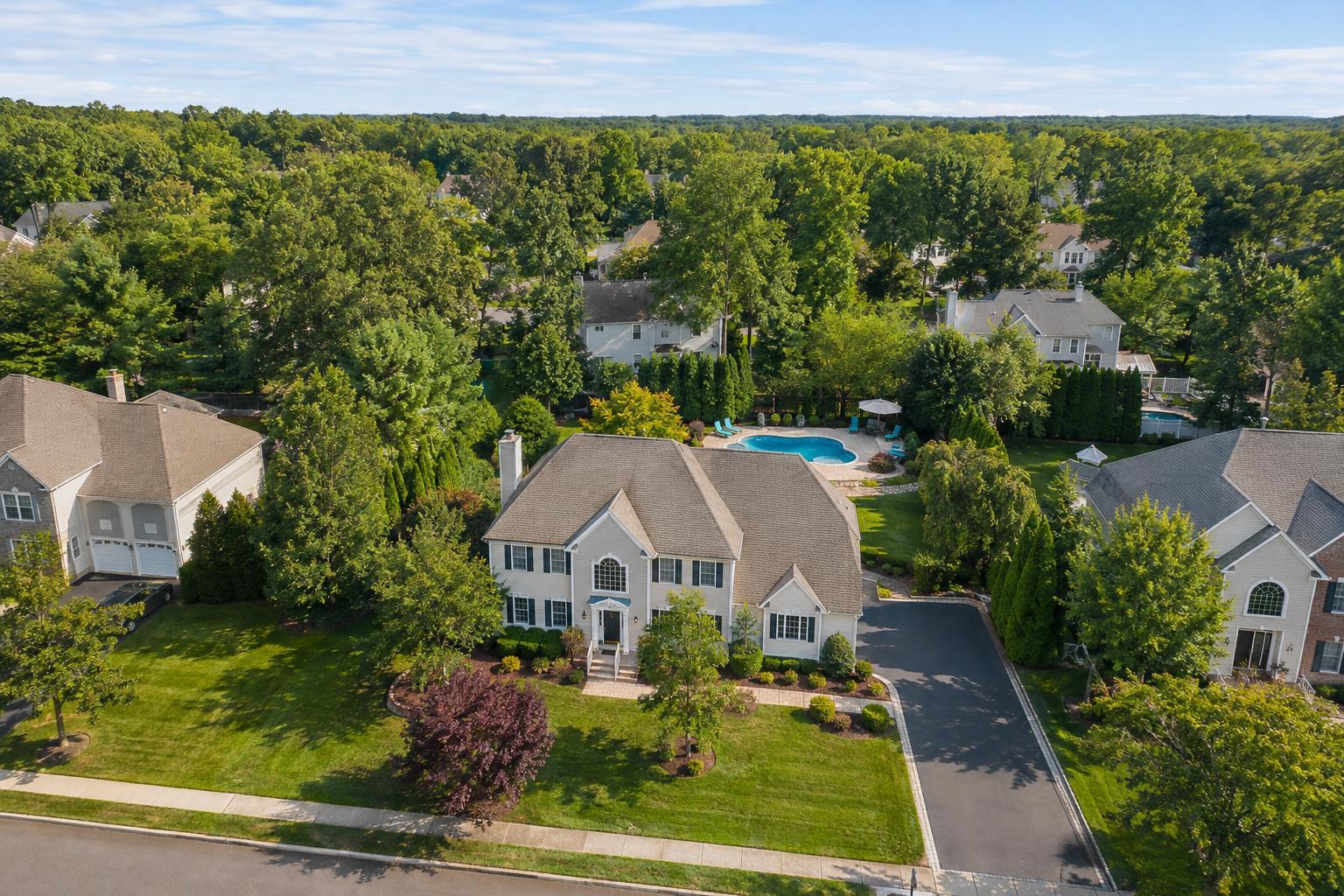
Drone photography in NJ captures a beautiful suburban neighborhood with spacious houses, lush greenery, and a backyard pool.

Drone Photography NJ: When to Add Aerial Media to Your Listing
Drone photography in NJ can do more than create dramatic, eye-catching shots—it can tell a clearer visual story where it really matters. For New Jersey agents and property marketers, the decision to add drone coverage is less about flash and more about substance: Will an aerial perspective make your listing easier for buyers to understand?
Let’s walk through the real considerations that make drone photography and aerial video especially valuable (and when you might not need it at all).
When Aerial Perspective Adds Real Value
Ground-level photography is the gold standard for most real estate listings. It conveys rooms, design, finishes, and curb appeal at eye level—the way visitors see them in person. Sometimes, that’s enough. But for certain properties, the full picture just won’t fit from the sidewalk.
Aerial media excels at answering questions ground-level images leave open, especially when size, setting, or location are selling points. A drone shot can convey:
- Lot boundaries and the overall layout, including patios, pools, and outbuildings
- How much land accompanies a home, or exactly where it rests relative to neighbors
- Waterfronts, shorelines, docks, and marina access
- Proximity to amenities—parks, beaches, golf, or transit
- Parking lots and entry points for commercial properties
- Architectural features you can only appreciate from above (think rooftop decks, solar panels, or modern rooflines)
- The broader neighborhood or natural setting
Height isn’t the only thing that matters. It’s about context—helping potential buyers quickly see the property’s relationship to what’s around it, so there are fewer surprises later.
Which NJ Properties Benefit Most from Drone Photography?
Not all listings need a bird’s-eye view. The biggest winners are properties where the setting or site layout is central to the sale. Examples include:
- Homes with Acreage or Estate Features: If you’re marketing a property with a long driveway, barns or guesthouses, or mature landscaping, aerial photography can show how everything fits together. Sometimes, a lower-altitude drone image captures the details while providing needed context in a single frame.
- Waterfront and Shore-Area Homes: Nothing beats an aerial photo for revealing a home’s relationship to water. You can show distance to the shoreline, orientation of docks, or the directness of beach access. It’s essential that these images reflect reality—never imply your listing has private waterfront if it doesn’t.
- Properties with Distinctive Roofs or Outdoor Features: Dramatic rooflines, green roofs, rooftop amenities, and large solar arrays are more easily explained from above. Aerials work best when they spotlight a unique architectural advantage, not just as abstract overheads.
- Commercial or Mixed-Use Sites: For commercial listings, drones capture the big picture—entrances, parking flow, loading areas, visibility from roads, and the scale of site improvements. Here, the value is clarity for buyers, not artistry.
- Extensive Outdoor Amenities: Tennis courts, wide patios, multi-level decks, or carefully designed gardens are tough to show in one ground photo. Drone shots connect all the dots.
On the flip side, listings like compact condos or rowhouses in densely packed areas might not benefit much from aerial media, especially when exterior context is limited.
Still Photography vs. Video: Different Tools, Different Stories
Aerial photography and aerial video both bring something different to the table.
Drone Stills are fantastic for:
- Listing galleries, social posts, and brochures where a single image needs to sum up context
- Hero shots that showcase home, yard, or waterfront at a glance
- Highlighting proximity to key exterior features (like a beach or park)
- Supplementing ground-level images with a new exterior angle
Drone Video shines when movement matters:
- Sweeping approaches to large homes or commercial sites
- Showing the entire site layout in one smooth motion
- Waterfront properties where a sense of flow and setting increases their appeal
- Providing an attention-grabbing opener or transition in a full property video
Pairing both, when justified, helps buyers engage visually and mentally—first pinpointing location and scale (with stills), then “touring” the grounds (with video).
RealtaSnap offers drone photo packages (10 HDR aerial images) for $209, aerial video (1-minute, 4K) for $229, or a bundled photo and video service for $299. These prices are based on on-site capture when conditions and regulations allow.
Special Considerations in New Jersey: From North Jersey to the Shore
New Jersey’s variety—urban density in the north, sprawling suburbs, and iconic Shore communities—affects the practicality and value of drone work.
- North Jersey Urban Areas: High density, major roads, and proximity to airports or heliports mean stricter airspace limits. Many urban sites can’t safely or legally accommodate drone flights, especially if there’s limited open space for launch and landing.
- Suburban Properties: Homes with larger lots, pool areas, gardens, or mature trees often benefit from aerials that show private outdoor spaces—not necessarily the whole neighborhood. The ideal image highlights the relationship between the house and its immediate surroundings.
- Shore and Waterfront Listings: Drones can deliver dramatic shots, provided weather, wind, and airspace restrictions are favorable. Coastal towns sometimes require extra caution, as even perfect weather on the ground doesn’t guarantee safe, legal aerial operations.
Drone Feasibility Always Comes First
Not every property is an automatic fit for aerial media. Drone flights depend on a real-world assessment of location, conditions, and local rules. Key factors:
- FAA regulations and airspace restrictions
- Weather (wind, precipitation, low visibility)
- Obstructions (trees, powerlines, densely packed buildings)
- Property access, building policies, and safety for both the drone and bystanders
- Busy roads, sidewalks, or public events nearby
At RealtaSnap, every drone request is evaluated individually—no one-size-fits-all guarantee. Mentioning what you aim to capture (waterfront angle, roof deck, parking configuration, etc.) when you book helps the team prioritize and plan.
Aerial Media Complements On-the-Ground Coverage
A drone shot should never replace ground photography; it should enhance your marketing kit. Pairing the two paints a more complete picture. For example:
- Waterfront listings: Show both a high aerial of the shoreline relationship and interior shots of the views
- Estates: Combine aerials of the grounds with room-by-room ground interiors and feature shots
- Mixed-use properties: Pair site-wide overviews with close-ups of access, parking, and indoor amenities
RealtaSnap provides complete on-site photography, video, and aerial media services for New Jersey real estate—so you can build a custom package that tells the full story. See more about RealtaSnap’s real estate photography services.
Planning Aerial Coverage: What to Ask Before Your Shoot
To get the best results from drone media—especially in NJ’s diverse settings—it pays to answer a few simple questions before you book:
- Does a bird’s-eye view clarify something buyers would want to know?
- Is there outdoor space, water access, or lot size that’s hard to capture from the ground?
- Will movement (aerial video) help demonstrate scale or connections between features?
- Are you hoping to show relationship to amenities like beaches, golf, or transit?
- Is drone operation feasible at the location based on regulations, weather, and access?
- Are there requirements for day-of access (rooftop, private dock, restricted common space)?
A short planning call with your media provider can streamline the process and avoid disappointments.
Booking Drone and Aerial Real Estate Photography in NJ
If you’re considering listing-focused aerial media in New Jersey, RealtaSnap offers tailored drone photography and video services with transparent pricing and a clear focus on property context. Whether you need dramatic aerials or a combination of ground and sky-level coverage, you can explore options, view sample galleries, or book online at www.RealtaSnap.com.
FAQ
Question: Does every property benefit from drone photography in NJ?
Answer: No. Drone imagery is most worthwhile when it helps buyers understand aspects like land, location, exterior features, water access, or a building’s site plan. Many compact properties or listings with limited outdoor space may be better served by quality ground-level photos.
Question: Can an aerial image show nearby amenities like parks or beaches?
Answer: Yes—when conditions, airspace, and flight feasibility allow, drone shots can illustrate proximity to parks, waterfronts, or transit. Images should accurately reflect what the property offers and never suggest private access or views unless they’re part of the listing.
Question: What if weather or regulations prevent a drone flight on the day of the shoot?
Answer: Drone work is always subject to day-of weather, FAA airspace rules, safety, property access, and pilot judgment. If a flight isn’t possible, discuss important visual priorities in advance—your provider can recommend alternate solutions when needed.
If you’d like to discuss drone options for an upcoming New Jersey listing, we’re happy to help. See what’s possible at www.RealtaSnap.com.