Drone Photography NYC: When Aerial Media Is a Practical Fit for Your Listing
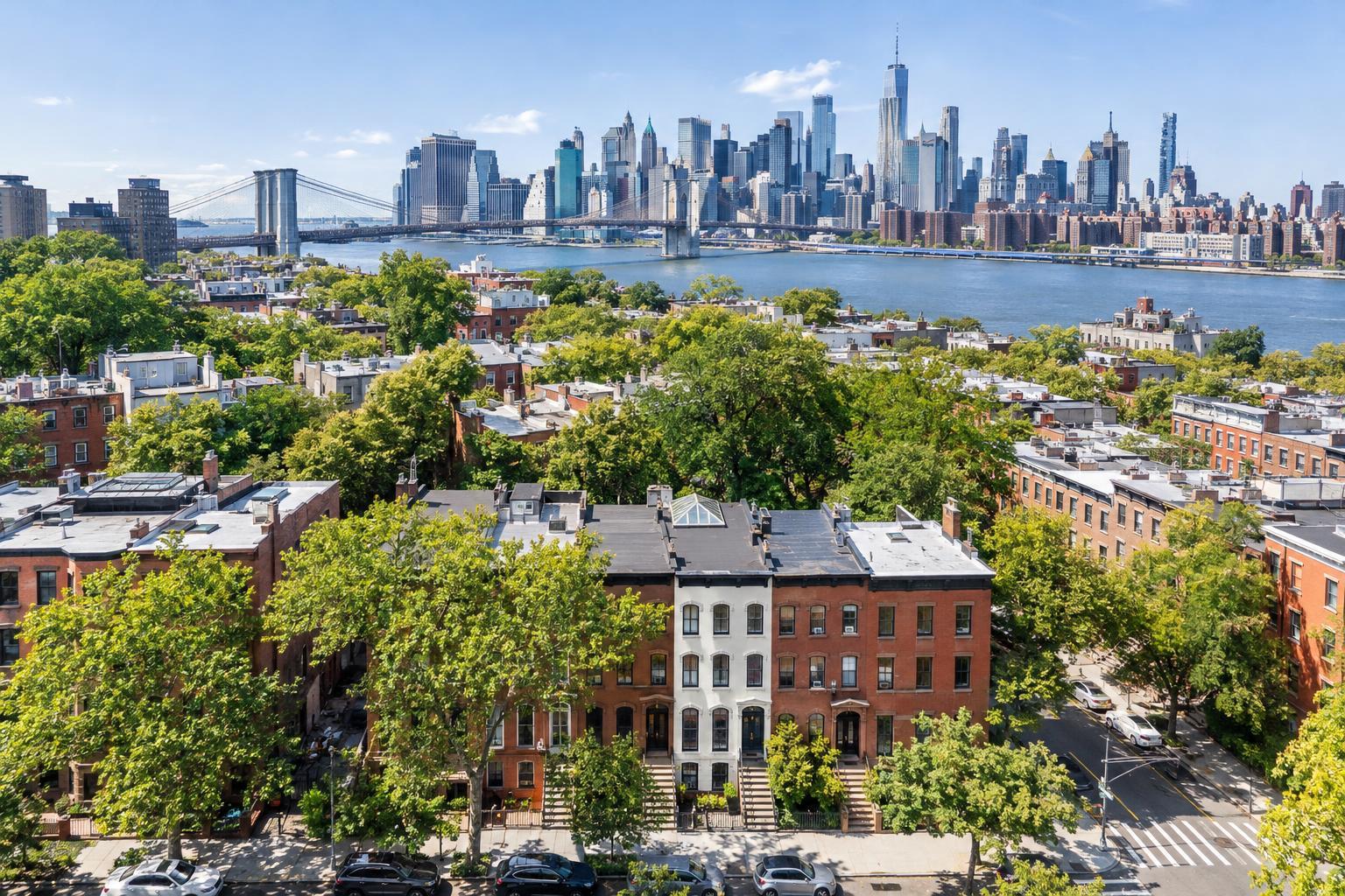
Drone photography captures a stunning view of NYC, showcasing a vibrant neighborhood in the foreground with the iconic skyline and Brooklyn Bridge in the background.

Drone Photography NYC: A Practical Approach for Real Estate Listings
Drone photography in NYC can be a powerful asset for real estate marketing—when it’s deployed with a clear purpose. In a city where every block hides a new challenge for aerial work, a strategy-first mindset matters. If you’re an agent, broker, developer, or property manager evaluating whether to add drone media to your next listing, the key isn’t just “Will it look cool?” It’s “Will it actually help my property stand out in a meaningful way?”
Let’s take a down-to-earth look at when aerial real estate photography makes sense, what you should prepare for in New York City and nearby New Jersey, and how to know if it’s a fit for your listing.
When Does Aerial Media Add Value?
Professional listing photos are a must for showing interiors, finishes, and flow. But ground-level media can’t always capture everything. Aerial photography and video become invaluable for listings where exterior context, outdoor amenities, or neighborhood placement play a central role.
Situations where drone imagery can make a difference:
- Private rooftop spaces, gardens, or large, landscaped yards
- Properties with distinctly shaped lots or multiple buildings
- Homes or buildings adjacent to water, parks, or major open spaces
- Corner locations or properties with unique architecture
- Commercial buildings, complexes, or sites with visible parking, driveways, and entry points
- Listings near key avenues, transit, bridges, or popular neighborhood destinations
For example: A townhouse with a rooftop deck and rear patio comes to life when a drone shot connects those features, rather than separating them into disjointed close-ups. Waterfront proximity, parking access, or a property’s position within the block come through clearly in a well-planned aerial sequence.
It isn’t about adding drama for its own sake. The point is to answer questions buyers or tenants might actually have—like, “How does the backyard connect to the rest of the lot?” or “What’s just beyond the property line?”
Why NYC Aerial Feasibility Is Not One-Size-Fits-All
New York real estate brings its own set of conditions. In lower-density cities or the suburbs, drone flights may be easier to arrange. Here in NYC, feasibility can change dramatically from one block to the next.
Aerial operations depend on:
- FAA airspace rules and safety guidelines
- The local environment: street width, pedestrian activity, and tall neighboring buildings
- Weather and visibility on the day of capture
- Site access and building cooperation, especially for rooftops
- Local restrictions and permit requirements
- The drone pilot’s assessment and discretion
Sometimes, it isn’t possible to fly. That’s why at RealtaSnap, each location is evaluated individually before confirming aerial coverage. Think of every address as a “case-by-case” scenario.
Manhattan: High Rewards, High Hurdles
Aerial shots in Manhattan can bring out rooftop amenities, terraces, proximity to landmarks, and unique architectural outlines. But challenges are just as real: tightly packed buildings, heliports, controlled airspace, heavy traffic, and stubborn access rules.
Rooftop access can improve the odds, but there’s never a guarantee. For many apartment listings, carefully staged interior and view photography may be both easier and more effective than pushing for drone footage where conditions are harsh.
Brooklyn, Queens, The Bronx, and Staten Island: More Breathing Room
Once you get into Brooklyn brownstones with gardens, multifamily buildings with shared outdoor areas, or homes in Queens, The Bronx, or Staten Island with large lots and parking, aerial shots often add real context. These areas offer more open sky, but every shoot still runs up against its own logistics: permission for launch sites, building staff requirements, events, or neighborhood rules.
New Jersey Properties: Land and Layout on Display
Just across the river, New Jersey listings—especially those with substantial land, driveways, or visible outdoor features—are strong candidates for drone coverage. Aerial video works well when you need to walk viewers through a long approach, highlight landscaped grounds, or show the footprint and flow of a larger home or commercial site.
Planning: What to Figure Out Before Requesting Drone Media
If aerial content could improve your listing, you’ll want to be prepared before requesting a feasibility review. Here’s what helps clarify whether a flight is worth pursuing:
- Full property address
- Listing type (e.g., townhouse, condo, commercial property, development)
- The exterior spaces or features you want to highlight
- Whether you’re seeking aerial photography, video, or both
- Access details, especially rooftop or outdoor spaces
- Who can assist with access (super, manager, building rep)
- Any known site limits (construction, events, policies, nearby hazards)
- Preferred shoot date and overall timeline
- Any must-have views, angles, or nearby landmarks to capture
Rooftop access is especially helpful in dense parts of NYC but isn’t a cure-all. There’s also a process for special permitting if a flight needs municipal or police approval. RealtaSnap does not pull permits beyond standard FAA requirements—if your project needs extra city permission, that has to be arranged separately.
Weather, Light, and Timing: The Creative Variables
Drone work happens on-site, in real conditions. Wind, rain, low clouds, or surprise construction can affect both flight safety and image quality. Lighting changes throughout the day can drastically affect how a property or its surroundings appear from the air.
- Mornings work nicely for east-facing features and less busy streets
- Afternoons are often best for west-facing outdoor spaces
- Midday light is even and documentary-style—ideal for broad site layout
- Late afternoon or early evening can add drama but require safe, workable conditions
If you have a particular view or outdoor feature in mind, specifying timing up front leads to better results.
Choosing Between Aerial Photos, Video, or Both
How you intend to use aerial content should drive your selection:
- Aerial photos make sense if you need a handful of powerful images to accompany the core listing gallery. They’re crisp and direct—excellent for showing location, outdoor space, or building scale.
- Aerial video is best when movement matters—maybe your property has a long entrance, sweeping waterfront, or layout that unspools naturally over a 30–60 second clip.
- Photo-plus-video bundles are natural fits if you’re already doing a property video and want aerial perspectives woven into the mix.
For current package details and booking options, visit RealtaSnap’s NYC drone services page.
Aerial Media: The Right Tool for the Right Listing
It’s worth repeating: drone coverage isn’t a mandatory add-on for every address. It excels when the property has meaningful exterior features, land, water, parking, or location context to show off. For many NYC apartments, the main photographic story will still come from interiors, building views, and staged vignettes.
Aerial media is not recommended for:
- Typical units without outdoor space or significant context from above
- Highly dense environments where no safe, legal takeoff sites exist
- Situations where the property’s selling points are entirely indoors
- Sites restricted by airspace, weather, or safety
When drone isn’t feasible, strong ground-level images, window views, and listing video can carry the marketing story.
Working with RealtaSnap: A Case-by-Case Partner
RealtaSnap provides drone photography and video for real estate marketing across all five NYC boroughs and throughout New Jersey, when it’s legally and safely possible. The first step is always to enter your property address and any drone requests during online scheduling. Each case is reviewed for airspace, site, and operational feasibility before confirming.
Drone pricing:
- 10 Aerial Photos – $209 (HDR, blue sky as needed, up to 1 hour on site)
- Drone Video (1 min) – $229 (4K, up to 1 hour on site)
- Photo & Video Bundle – $299 (10 photos + 1 minute video, up to 1 hour on site)
For more details or help planning your media approach, visit www.RealtaSnap.com.
FAQ
Question: Can a drone fly anywhere in New York City?
Answer: No. Every location in NYC has its own restrictions and variables—from FAA rules to access, weather, building cooperation, and pilot assessment. Feasibility is always evaluated one address at a time.
Question: Does having roof access guarantee aerial media is possible?
Answer: Roof access often improves the chances, especially in dense areas, but it’s not a guarantee. The surrounding airspace, weather, building rules, and site safety still govern what’s possible on the day of the shoot.
Question: Should I order drone photos, video, or both?
Answer: Choose photos if you want standout shots for your image gallery. Opt for video if you need to show movement or walk viewers through an exterior space. Both can work well together if the listing supports it or if you’re already planning an on-site video session.
If you have an upcoming listing where aerial context could help, RealtaSnap would be happy to review feasibility and options with you.
www.RealtaSnap.com