When Is Drone Photography Worth Adding to a New Jersey Real Estate Listing?
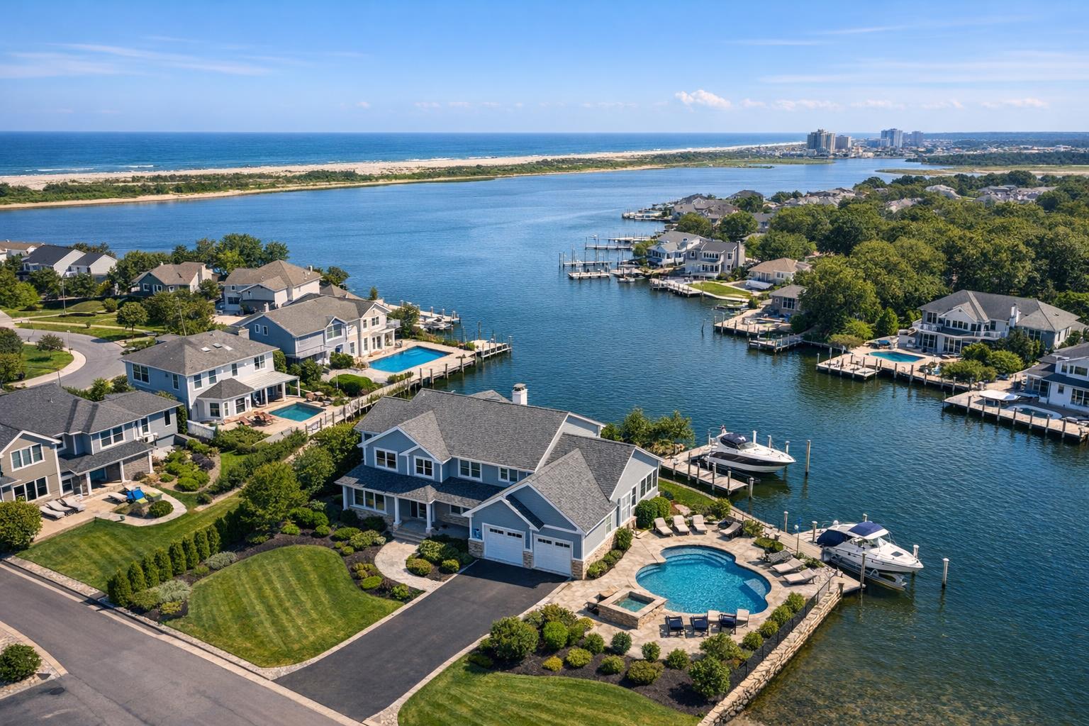
Drone photography in NJ captures a picturesque view of waterfront homes with private docks and pools, set against a serene coastal backdrop.

When Is Drone Photography Worth Adding to a New Jersey Real Estate Listing?
Drone photography in NJ can be a powerful piece of a real estate listing—when the property's features call for it. For many New Jersey agents, brokers, developers, and property owners, the choice comes down to this: Will an aerial view help buyers see details, context, or value that regular ground photos can’t show?
Let’s look at when aerial shots tend to make a real impact, the kinds of NJ properties that benefit most from real estate drone photography, when it might be unnecessary, and what to consider before scheduling your next shoot.
Why Use Aerial Real Estate Photography?
Traditional, ground-level photos are fantastic for clear curb appeal, detailed exterior shots, and interior highlights. But an aerial perspective can reveal things you just can’t capture from the sidewalk—like the full relationship between a home, its lot, and its surroundings.
Aerial media can show:
- The exact size and boundaries of the property
- Proximity to shorelines, parks, golf courses, or other amenities
- How the house and outbuildings are arranged on the land
- Rooflines, layout patterns, and architectural features
- Parking, driveways, and entrances that can’t be seen from ground level
- A multi-building site or commercial footprint in a single frame
- The unique setting of a waterfront or view property
The value comes from clarity, not just drama. Drone shots can answer real buyer questions: Where are the closest walking paths? How far is the dock from the house? Does the yard connect directly to the open parkland? If the aerial perspective reveals answers, it’s often worth considering.
Which New Jersey Properties Tend to Benefit from Drone Media?
New Jersey offers a wide range of real estate, and not every property calls for a drone. Here’s where aerial real estate photography tends to shine.
Suburban Homes and Estates with Large Lots
Standard photos can make big yards or deep lots look smaller and more ordinary than they are. An aerial view can neatly explain:
- The size, shape, and usable space of the lot
- Private drives, extensive landscaping, or wooded areas
- Outdoor amenities like pools, barns, and sports courts
- How the house is placed on the land—or how detached structures relate to each other
This perspective can define what makes a listing special, even if you don’t show every inch.
Jersey Shore and Waterfront Properties
Waterfront homes are about more than interior upgrades—they’re about location. Drone photography can highlight:
- The home’s precise position on the water
- Docks, boat slips, and the distance to open bay or ocean
- Relationship to beaches, boardwalks, or water views
- Lagoon, canal, or peninsula setting for standout context
Aerials are particularly useful when location and orientation are the main attractions.
Distinctive Architectural Homes
Some homes—modern builds, historical gems, or those on unique lots—are best understood from above. A drone shot can clarify complex rooflines, geometric footprints, multiple terraces, or features you just can’t see from the street.
Multifamily and New Development Listings
For apartment buildings, new construction, or mixed-use sites, context matters. Drone imagery can frame:
- The building’s size compared to neighbors
- Onsite and offsite parking, entrance points, surrounding blocks
- Outdoor common areas or amenities spread across a site
Aerial photos can make it easy for buyers or tenants to grasp what’s being offered.
Commercial Sites
Industrial buildings, retail campuses, offices, and land parcels often need more than beauty—they need orientation. Real estate drone photography can make it easy to show parking, truck circulation, lot boundaries, and relationships to nearby businesses.
When Standard Exterior Photography May Be Your Best Bet
Not every property needs a bird’s-eye view. Sometimes, a simple ground photo tells the story more clearly. Consider sticking with traditional photography if:
- The lot is small and surrounded by similar homes
- Interior design and finishes are the main selling points
- The home is in a dense area with little visual separation
- Street trees or neighboring buildings block useful aerial views
- The best features can be captured easily from sidewalk level
For a compact condo, for example, interior and floor plan images or a quick video walkthrough often work much better than drone shots.
The right listing media should simplify things for buyers—not just add more images for the sake of it.
Is Drone Media Feasible for Your New Jersey Listing?
Even when aerial shots would help tell the story, a drone flight isn’t always possible. FAA rules, airspace classification, weather, site access, and safety all play a part. Urban rooftops can sometimes offer safer launch points. For waterfront listings, wind and weather on the day of the shoot matter.
RealtaSnap reviews feasibility property-by-property. Some neighborhoods, especially near airports or in restricted zones, require advance approvals. If extra municipal permits are required, those are managed by the client, not RealtaSnap.
This hands-on review process isn’t a drawback. It’s how responsible real estate drone photography should work—every shoot needs to be both safe and legal.
You can learn more or get started by visiting RealtaSnap’s drone service page.
Making the Choice: When Does a Drone Shot Add Value?
Before booking aerial coverage, zoom out—literally and figuratively. Think about what a street-level camera can’t communicate.
Consider aerial photography if:
- Land size, water position, or property orientation is a key selling point
- Outdoor amenities deserve high-level perspective
- Commercial sites or multifamily buildings need context buyers can’t get from the curb
- The relationship between the home, outbuildings, features, and neighbors tells an important part of the story
If you realize the main appeal is an updated kitchen or a cozy interior, you’re probably better off with standard listing photos and possibly a floor plan or video tour.
Drone Photos, Drone Video, or Both?
Still images and video aren’t interchangeable. Aerial photos are excellent for easily digestible, shareable context: “Here’s how this property sits on the water,” or “Here’s the big backyard you can’t see from the curb.” Video, on the other hand, can walk a viewer around the site—showing approach, transitions, or scale through smooth motion.
A waterfront listing might use a mix: stills to clarify location and a short aerial video to sweep past the shoreline and show off the setting. RealtaSnap offers three aerial media options for qualifying properties:
- 10 HDR drone photos (with sky replacement if needed): $209
- 1-minute edited 4K drone video: $229
- Combined package (photos + video): $299
The right call depends on how much of the listing’s appeal comes from above. Sometimes, a few well-chosen aerial images are all you need. Larger estates, new developments, or destination properties can take advantage of both.
Prepping for an Aerial Shoot
A drone sees everything—driveways, rooftops, sheds, the lot next door. Help your listing look its best by handling:
- Stowing vehicles, bins, hoses, and yard tools
- Tidying pool areas, decks, and patios
- Arranging or straightening outdoor furniture
- Removing covers, clutter, or temporary construction items
- Safeguarding anything that shouldn’t appear in marketing photos
For commercial properties, be mindful of delivery schedules, parked trucks, and signage. Aim to present the property as inviting and distraction-free, without making it feel artificial.
RealtaSnap: Aerial Media, Done Responsibly
Drone photography should work in service of your listing—not the other way around. When a bird’s-eye view adds clarity, scale, or context, it’s a smart investment. When it’s just more pictures of rooftops, it can distract from what really matters.
If you’re planning a listing in New Jersey that could benefit from aerial media, RealtaSnap can review the site, confirm feasibility, and help put together a shoot that highlights the best of your property. Explore options or start the process at www.RealtaSnap.com.
FAQ
Question: Can every New Jersey property get drone coverage automatically?
Answer: No. Each drone shoot depends on FAA regulations, airspace restrictions, weather, safety, access, local rules, and pilot discretion. RealtaSnap evaluates every site to see if a safe, legal flight is possible.
Question: Is aerial photography worth it for small homes or condos in New Jersey?
Answer: Sometimes. If the listing has a private yard, notable location, or something compelling the drone can show, it might be helpful. But most compact homes benefit more from sharp ground-level photography, a floor plan, or a well-made walkthrough.
Question: What’s included in a standard RealtaSnap drone media package?
Answer: RealtaSnap’s basic aerial options are 10 HDR drone photos for $209, a 1-minute professionally edited 4K drone video for $229, or both photo and video for $299. All services require property and flight feasibility approval. For more details, visit RealtaSnap’s website.