When Is Drone Photography Worth Adding to a New Jersey Real Estate Listing?
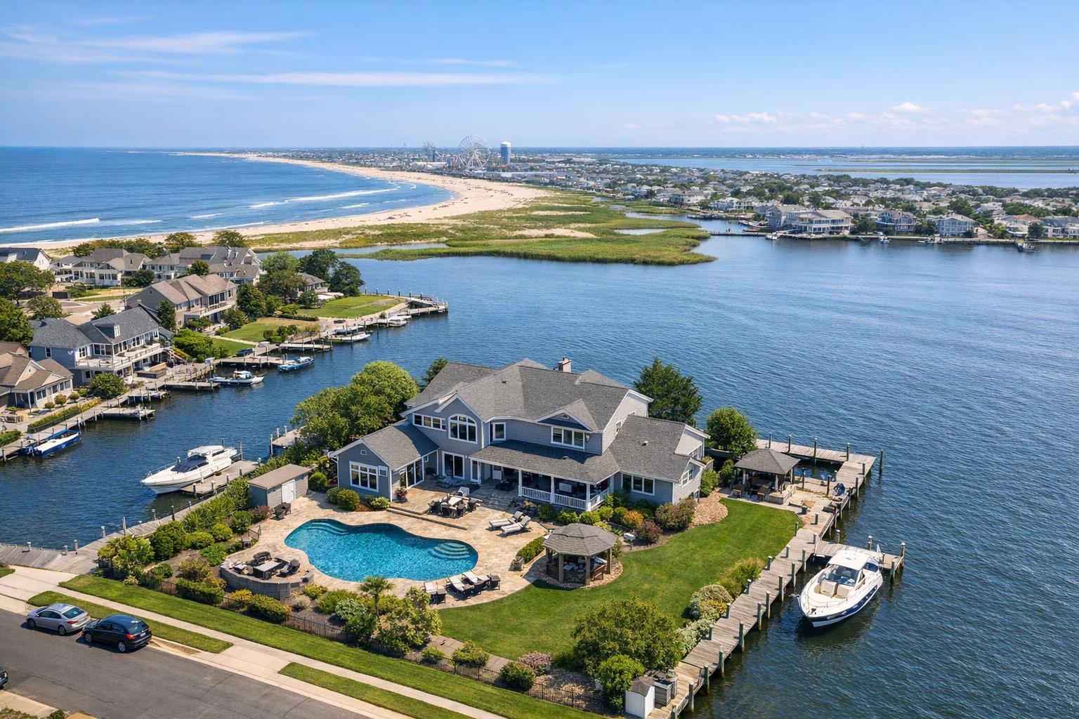
Captured through drone photography in NJ, the image showcases a luxurious waterfront home with a pool and private docks, set against a backdrop of beach and ocean views.

When Is Drone Photography Worth Adding to a New Jersey Real Estate Listing?
Drone photography in NJ has quickly shifted from a novelty to an everyday request among real estate agents and property marketers. Yet, not every listing benefits equally from an aerial view. The real question isn’t whether drone technology is available—it’s whether aerial media adds real, useful context that ground-level photos simply can’t capture.
Let’s dig into when drone imagery brings value to a New Jersey listing, which property types see the most impact, and what practical factors to consider before scheduling a flight.
Does Your Listing Need an Aerial Perspective?
A stunning drone shot grabs attention, but the best use of aerial photography does more than add visual flair. Consider what a bird’s-eye view explains that a street-level image cannot.
For instance:
- How a home sits on a unique lot or showcases a spacious yard
- Waterfront location, private docks, or proximity to beaches, marinas, or inlets
- Expanded views of roof decks, upper terraces, or distinctive architectural elements
- Relationship to local parks, transit, business districts, or major roadways
- Layout of exterior amenities like pools, sport courts, barns, or parking lots
If the answers to important buyer questions—like land size, privacy, outdoor features, or access—are unclear from standard images, an aerial photo or video might be the right move.
Types of Properties That Benefit Most
New Jersey’s diversity shows in its real estate. From urban multifamily buildings and suburban homes to Jersey Shore getaways and sprawling estates, the need for aerial media changes based on setting and features.
Larger Lots and Estates
Suburban and semi-rural homes with sizable yards, long driveways, or multiple structures often look cramped or ambiguous in street-level images alone. Aerial real estate photography lets agents reveal:
- The true scale of lawns, gardens, patios, or wooded acreage
- Placement of guest houses, detached garages, or workshops
- Outdoor amenities like pools, courts, or recreation areas
- Privacy created by landscaping or distance from neighbors
For compact lots or dense developments, however, a strong set of professional ground photos can usually tell the story just as clearly.
Shorefront and Waterfront Properties
Jersey Shore listings are often tailor-made for drone photography. Aerial views can clearly position a property in relation to the water’s edge, a bayfront dock, or public beach access—no imagination needed. Agents gain selling points with images that highlight:
- Water frontage, private docks, and bulkheads
- Boardwalk proximity or unique view corridors
- Rooftop decks facing the ocean, bay, or city skyline
- How a home or condo relates to the larger shore or island community
It’s worth noting: drone flights near water require extra attention to weather, wind, and local conditions on flight day.
Unique Architecture, Roof Decks, and Views
Some properties are best understood from an elevated angle—their most impressive features might be a wraparound deck, a hillside perch, or a geometric roofline you can’t fully appreciate from the driveway. Aerial photography helps illustrate:
- Distinctive roof shapes or architectural footprints
- Elevated outdoor living spaces
- How a home takes advantage of a slope or bluff
- The panorama offered from a roof deck
For classic townhomes, apartments, or homes whose strengths are inside or at curb level, ground shots may do the listing better justice.
North Jersey Multifamily and Urban Sites
In the crowded markets of North Jersey, drone photography has its place—especially for multifamily, condo, or mixed-use buildings where showing a footprint, rooftop amenities, parking layout, or context within a neighborhood is important.
Urban settings pose added complexity: high-rises, power lines, busy streets, and airspace rules may restrict what’s possible. Still, smart aerial media can help a buyer visualize location and accessibility in a way that interior shots alone never could.
Commercial Properties That Rely on Scale
Large retail centers, warehouses, office parks, or land listings are often hard to understand from the ground. Drone photos and videos can quickly display entry points, parking, nearby infrastructure, and property boundaries. For commercial or mixed-use listings, the story is often about:
- Amount and type of parking or loading space
- Access from highways or transit
- Relationship to neighboring business districts or industrial parks
- Overall footprint in the local area
When Standard Exterior Photography Is Enough
Adding a drone simply because it’s possible doesn’t always improve buyer understanding. Some properties may be best served by professional exterior and interior photography if:
- The lot is standard size, with few exterior features worth highlighting
- Neighbors’ homes surround the property with little separation
- The main selling points are indoors or at curb level
- No views, roof decks, or outdoor amenities make an aerial worthwhile
For many apartments, smaller townhomes, and listings without land, water, or unique views, a well-crafted gallery of ground-level images may be more valuable.
Practical Considerations for Drone Flights
Even when drone media seems like the right fit, feasibility can’t be guaranteed until day-of. Safe, legal flights depend on several factors:
- Airspace: Some areas need FAA clearance or may be restricted altogether.
- Weather: Wind, rain, low visibility, and harsh light impact both safety and final image quality.
- Launch Space: Pilots need clear, safe spots to operate without risking people, vehicles, or property.
- Urban Density: Crowds, tall structures, utility wires, and traffic add complexity—especially in busy North Jersey markets.
- Property Access: Gaining access to rooftops, backyards, or open land often unlocks better capture options.
- Local Rules: Permits beyond standard FAA approval may be needed in some towns or cities. Clients are responsible for any special permits if required.
Every drone request should be reviewed individually. RealtaSnap evaluates feasibility for each address before confirming that an aerial flight is possible.
Making the Most of Your Drone Appointment
A little prep ensures you get meaningful aerial images. Before your scheduled appointment:
- Move vehicles from driveways if possible
- Tidy up patios, decks, and pool areas
- Put away trash bins, hoses, and temporary signs
- Double-check that outdoor spaces, gates, docks, and desired features are accessible
- Tell your media team up front if a specific angle, view, or feature is a must-have
The order of image capture can matter. Drone images often work best as complements to classic exteriors—providing wider context after curb appeal is already established by standard shots.
Choosing What to Order: Photos, Video, or Both?
Aerial stills and video each have their own strengths:
- Aerial photos are flexible for galleries, brochures, websites, or social media, and can be captured at a range of heights and angles.
- Drone video is ideal for listings where motion tells the story—revealing waterfront locations, approaches to roof decks, or the sweep of a commercial site.
Many agents benefit from a bundled approach—10 HDR aerial photos plus a one-minute 4K video covers both gallery and motion needs in one visit.
Current RealtaSnap pricing (always check the latest NJ info):
- 10 HDR aerial photos (blue sky replacement included if needed): $209
- 1-minute final 4K drone video: $229
- Both: $299
Is Drone Media Right for Your New Jersey Listing?
If you’re deciding whether to add aerial coverage to your next marketing package, ask yourself:
- Does the property have exterior features or a setting that can’t be easily shown from the ground?
- Would an overhead or elevated angle help buyers understand key points?
- Is there a good chance that a safe, compliant flight can be made at this location?
If two or more of these ring true, it’s worth considering drone coverage—just make sure your booking includes the property details and any exterior priorities.
For New Jersey listings with meaningful land, water, views, or commercial scale, RealtaSnap’s aerial media helps agents build a visual narrative when conditions are right. Learn more or book your next session at RealtaSnap’s NJ real estate photography page.
Ready to add drone footage or want to discuss what’s possible in your area? Visit www.RealtaSnap.com.
FAQ
Question: What does RealtaSnap charge for drone photography in New Jersey?
Answer: RealtaSnap’s rates are $209 for 10 HDR drone photos, $229 for a one-minute final 4K video, and $299 for the photo and video package. All drone shoots are subject to weather, airspace, location, access, and pilot approval.
Question: Can I add drone photography to any type of property in North Jersey?
Answer: Drone media can be especially helpful for larger buildings, condos, and commercial sites where aerial photos clarify things like layout, parking, and location context. Urban density, airspace, and safety rules mean each property is reviewed for feasibility.
Question: Should I schedule aerial and standard photos separately?
Answer: Most clients find it easiest to book both at once. When scheduling, provide the property address, access details, and any features you want covered. RealtaSnap will coordinate the coverage as part of your listing’s media appointment.