When Is Drone Photography Worth Adding to a New Jersey Real Estate Listing?
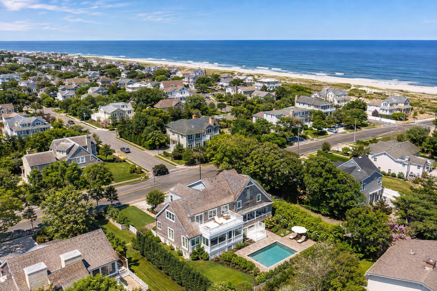
Aerial drone photography in NJ captures a scenic view of a coastal neighborhood with beautiful homes, lush greenery, and the beach stretching alongside the ocean.

When Is Drone Photography Worth Adding to a New Jersey Real Estate Listing?
Drone photography in NJ offers real estate professionals a unique way to highlight properties, but the real value comes from using aerial images when they genuinely reveal something you can’t show any other way. The best use of aerial media isn’t about adding flair for every listing—it’s about providing meaningful context to buyers, tenants, or investors who want to better understand a property before they visit.
Let’s dig into when drone imagery really makes sense, what makes for a strong aerial story, and how to decide if it’s the right move for your New Jersey listing.
Where Drone Imagery Truly Shines
Before considering drone photography, ask yourself: “Does this listing have features that are hard to capture from ground level?” Aerial images are especially useful for properties where exterior aspects, lot size or arrangement, water access, or unique surroundings add value.
Common scenarios where aerial media adds practical clarity:
- Large lots with unique landscaping or multiple amenities
- Waterfront homes offering dock access, beaches, or wide water views
- Properties on dramatic sites—think mountain, skyline, or ocean views
- Distinctive architecture, especially roof design, terraces, or courtyards
- Proximity to parks, transit, retail corridors, or recreation—if visibly relevant
- Commercial, industrial, or mixed-use sites where access, circulation, and visibility matter
- New development projects needing to show site context
If the aerial perspective helps buyers better understand a property’s setting or layout, drone media is worth considering.
Matching Property Types to Aerial Media
Across the Garden State, listings range from tight urban condos to sprawling shore homes. Not every property benefits from a flyover, but some shine from above.
Spacious Suburban Homes
In North Jersey’s suburbs, homes set on deep lots with features like pools, outdoor kitchens, and tree lines often warrant drone photos. Aerial shots can tie the home and landscape together, showing privacy, layout, or landscape design—all details that matter in these neighborhoods.
Waterfront and Shore Listings
Drone coverage is a natural fit for Jersey Shore homes with real access to water. Overhead photos or wide-angle views can make clear how the property sits relative to the bay, marina, or beach. Including shots that connect pools, decks, or roof terraces to the shoreline helps buyers appreciate the lifestyle offered.
Weather counts here, too. Wind, rain, and coastal haze all play a role in scheduling and the look of finished photos.
Urban: Jersey City and Hoboken
In high-density areas, aerial shots aren’t always the star. But if the property boasts a rooftop terrace with city views, is part of a large redevelopment, or offers unique architecture, a drone can illustrate the connection to nearby parks, the Hudson River, or local transit in ways ground shots can’t.
Practical restrictions increase in cities—restricted airspace, safety, crowd activity, and roof access all play into what’s possible.
Commercial, Industrial, and Mixed-Use Sites
For commercial real estate, context can make or break the listing. Drone photos can clarify building arrangement, parking flow, access points, proximity to highways, and even the mix of surrounding businesses.
For retail: aerial images might highlight corner visibility and surrounding pedestrian routes.
For industrial: they reveal truck access, yard space, or how multiple buildings relate on a large site.
In all cases, the goal is to help viewers see the “big picture,” not just offer an overhead view for effect.
When Ground Photography Does the Job
Some properties simply tell their story better from the ground. If a home’s main appeal lies in renovated interiors, a modern kitchen, bright natural light, or a flexible layout, interior photos (and a strong floor plan, if available) should be the focus. Compact townhomes or apartments without significant outdoor context often don’t need drone coverage.
Budget, too, is part of the decision. It often pays to reserve aerial media for listings where the view from above adds real, practical value buyers wouldn’t see otherwise.
Different Purposes: Aerial Stills vs. Drone Video
It’s easy to lump aerial media together, but still photos and drone videos serve different roles.
- Aerial stills are typically featured in listing galleries, digital brochures, and social media. They’re perfect for letting buyers pause on a wide shot that tells them where the home is, how a lot is laid out, or what distinguishes the setting.
- Drone video introduces movement—think flying over a waterfront, circling a development site, or gliding from a neighborhood park to a building’s entrance. Used well, video showcases how a property connects to its surroundings, and works best as part of a complete video tour that also includes ground and interior footage.
RealtaSnap captures both stills and true on-site video footage (not just slideshows), so you get smooth, informative perspectives that support your listing’s story.
Planning for a Successful Drone Shoot
A drone sees more than a camera at the front door. Before scheduling, it’s smart to prep the property exterior—especially anything visible from the air:
- Move cars from driveways, parking areas, and curb spaces where possible
- Remove trash bins, hoses, yard tools, and loose items
- Tidy up patios, decks, and pool spaces
- Mow lawns and refresh landscaping as needed
- Shut unused garage or shed doors
- Secure lightweight décor or umbrellas that might blow in the wind
- Notify tenants, building management, or occupants in advance
- Confirm access to roof decks, common areas, or gated lots, if relevant
Effective prep ensures your aerial images tell a professional story from every angle.
Flight Feasibility: Not Every Location Is Ready for Takeoff
Drone operations aren’t “book and forget.” Every listing is subject to FAA compliance, airspace classifications, local restrictions, weather, and safety factors. RealtaSnap pilots review each location on a site-by-site basis—and not every address is guaranteed flyable.
Important considerations include:
- Controlled or restricted airspace (especially near airports or in dense downtowns)
- Safety and feasibility for launching and landing
- Proximity to crowds, traffic, power lines, tall trees, or other obstacles
- Weather: wind, visibility, and forecast conditions
- Required access to rooftops, yards, or secured locations
Even where roof access helps, it may not guarantee a flight—pilot discretion is essential. For locations that need special municipal permits, RealtaSnap does not obtain these directly; clients are responsible if such permits are needed for marketing purposes.
Making the Right Call: Building Drone Media into Your Listing Plan
Drone coverage works best when you have a specific visual story to show. As you plan your listing, consider:
- What do buyers need to see from above to appreciate this property?
- Are there exterior features, land, or a neighborhood connection that a map or brochure can’t fully explain?
- Will aerial photos or video supplement—not replace—strong ground and interior photography?
Aim for a balanced aerial gallery with:
- Broad context images showing the property in its true setting
- Detailed shots of amenities or standout lot features
- Architectural angles highlighting rooflines or key outdoor spaces
If you decide to move forward, working with a professional real estate media service like RealtaSnap ensures your drone coverage is planned, safe, compliant, and tuned to your listing’s unique needs.
You can learn more about RealtaSnap’s New Jersey real estate media services or book directly online.
FAQ
Question: When does it make sense to use drone photography for a standard suburban home in NJ?
Answer: Drone images are most valuable if the home’s layout, lot size, outdoor amenities, or privacy features aren’t clear from ground-level photos. For a typical property without major exterior features, strong ground photography usually covers the essentials.
Question: Can drone photos accurately show nearby parks, beaches, or transit?
Answer: Aerial images can include nearby amenities if they’re genuinely visible from a legal and practical flight path, but should never mislead buyers about distance or access. Honest context is key to effective marketing.
Question: What could prevent a scheduled drone shoot from happening?
Answer: Flights depend on several factors: legal airspace clearance, weather, property access, and pilot judgment. Wind, rain, crowd activity, obstacles, or access issues can all delay or cancel a flight onsite.
To see if drone photography is right for your upcoming New Jersey listing—or to schedule a session—visit www.RealtaSnap.com.